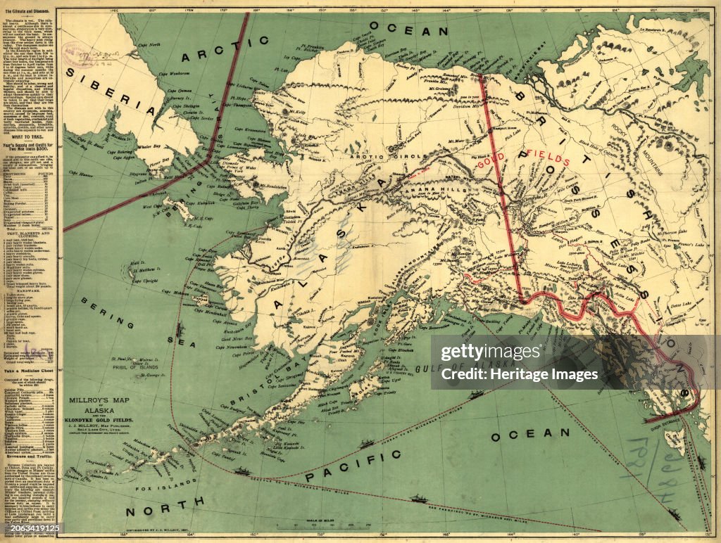
Millroys Map Of Alaska And The Klondyke Gold Fields
Millroy's map of Alaska and the Klondyke gold fields, 1897. The Klondike Gold Rush of 1898 began in earnest within 18 months of a major gold strike on Bonanza Creek, a tributary of the Klondike River near Dawson City, Canada. A mapmaker from Salt Lake City, J.J. Millroy, created this guide to the Klondike gold fields in 1897 using government and private surveys. The map was intended for use by the many prospective miners who soon were to descend upon the Yukon from around the world. The map shows the major routes to the Klondike gold fields (in red), including the Chilkoot, Chilkat, Copper River, Yukon River, Taku River, and Stikine River Routes. The map also highlights major shipping routes and the exact mileage from San Francisco and Seattle to Juneau and to various other points in Alaska that provided the best access to the interior routes to the Klondike gold fields. The map also shows mountain ranges with elevations marked in feet, bodies of water, and significant towns and cities in Alaska and Canada. Creator: J. J. Millroy. (Photo by Heritage Art/Heritage Images via Getty Images)

EINE LIZENZ KAUFEN
Wie darf ich dieses Bild verwenden?
335,00 €
EUR
Getty ImagesMillroys Map Of Alaska And The Klondyke Gold Fields, Nachrichtenfoto Millroys Map Of Alaska And The Klondyke Gold Fields Erstklassige Nachrichtenbilder in hoher Auflösung bei Getty ImagesProduct #:2063419125
 Millroys Map Of Alaska And The Klondyke Gold Fields Erstklassige Nachrichtenbilder in hoher Auflösung bei Getty ImagesProduct #:2063419125
475€150€
Getty Images
In stockBitte beachten Sie: Bilder, die historische Ereignisse darstellen, können Motive oder Beschreibungen beinhalten, die nicht der gegenwärtigen Auffassung entsprechen. Sie werden in einem historischen Kontext bereitgestellt. Weitere Informationen.
DETAILS
Einschränkungen:
Bei kommerzieller Verwendung sowie für verkaufsfördernde Zwecke kontaktieren Sie bitte Ihr lokales Büro.
Bildnachweis:
Redaktionell #:
2063419125
Kollektion:
Hulton Archive
Erstellt am:
1. Januar 1900
Hochgeladen am:
Lizenztyp:
Releaseangaben:
Kein Release verfügbar. Weitere Informationen
Quelle:
Hulton Archive
Objektname:
3004062
Max. Dateigröße:
6549 x 4936 px (55,45 x 41,79 cm) - 300 dpi - 22 MB
- 1890-1899,
- 1897,
- 19. Jahrhundert,
- Alaska - US-Bundesstaat,
- Arktis,
- Berg,
- Bergbau,
- Bergwerk,
- Bibliothek,
- Farbbild,
- Farbton,
- Finanzwirtschaft und Industrie,
- Fluss,
- Fluss Klondike,
- Fluss Stilkine,
- Fotografie,
- Gebirge,
- Geschichtlich,
- Goldmine,
- Goldrausch,
- Goldrausch am Klondike River,
- Golf von Alaska,
- Herstellendes Gewerbe,
- Horizontal,
- Karte - Navigationsinstrument,
- Kongressbibliothek,
- Küste,
- Meer,
- Neunzehntes Jahrhundert,
- Nordamerika,
- Nordpolarmeer,
- Pazifik,
- Physische Geographie,
- Richtung,
- Russland,
- Sibirien,
- Text - Schriftsymbol,
- USA,
- Vermischtes,
- Yukon,